
- Meštianske domy historického centra (mestská pamiatková zóna)
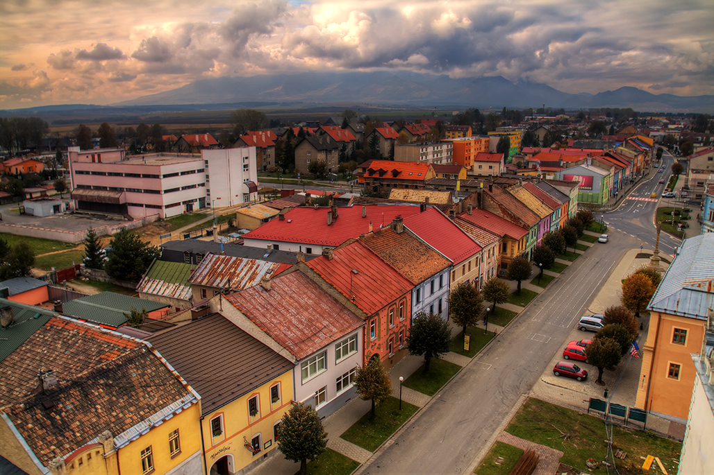
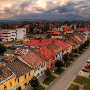
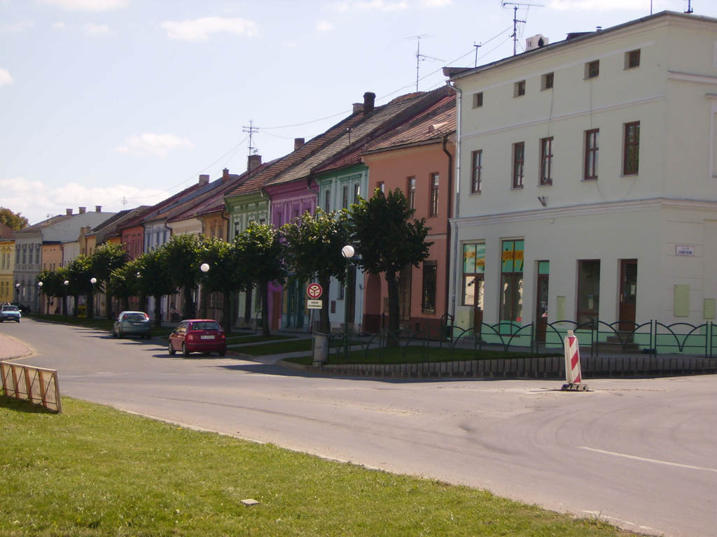
![]() Nemeckí kolonisti v 12. – 13. storočí v priestore terajšieho intravilánu Spišskej Belej nemali potok. Museli si ho priviesť ako kanál z krasovej vyvieračky Šumivý prameň z oblasti terajšej Tatranskej Kotliny. Pôvodné zastavané osídlenie malo vretenovitý pôdorys. Tvorili ho dve domoradia – tzv. zimná a letná strana. Boli postavené na úzkych stredovekých parcelách, ktoré pokračovali ďalej do hĺbky chotára. Priestor pri kanáli (potoku), kde boli 3 mestské mlyny s vodnými náhonmi, sa sekundárne zastaval drobnou zástavbou tzv. domkárov (chudobných nemešťanov). Tí vlastnili len dom a pozemok pod ním. Táto mestská časť sa volala medzi jarky.
Nemeckí kolonisti v 12. – 13. storočí v priestore terajšieho intravilánu Spišskej Belej nemali potok. Museli si ho priviesť ako kanál z krasovej vyvieračky Šumivý prameň z oblasti terajšej Tatranskej Kotliny. Pôvodné zastavané osídlenie malo vretenovitý pôdorys. Tvorili ho dve domoradia – tzv. zimná a letná strana. Boli postavené na úzkych stredovekých parcelách, ktoré pokračovali ďalej do hĺbky chotára. Priestor pri kanáli (potoku), kde boli 3 mestské mlyny s vodnými náhonmi, sa sekundárne zastaval drobnou zástavbou tzv. domkárov (chudobných nemešťanov). Tí vlastnili len dom a pozemok pod ním. Táto mestská časť sa volala medzi jarky.
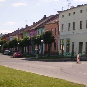
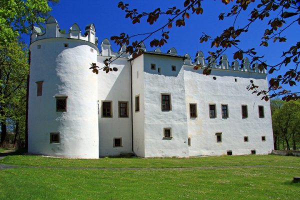
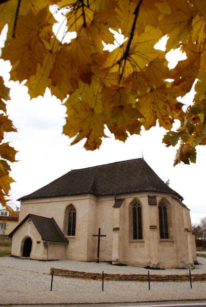
Dominantu mestečka vytváral kostol so zvonicou. Domy okolo námestia v 15. a 16. storočí boli troj – až päťosové, prejazdového alebo priechodového typu. Ich ráz určil život a spôsob živobytia jeho majiteľa. Stoja na typických stredovekých parcelách, úzkych a pretiahnutých do hĺbky. Pôvodne mali len prízemie, na poschodí boli sýpky a skladiská, len neskoršie sa nadstavovali aj obytné poschodia. V zadných traktoch domov boli hospodárske budovy, ktoré tvorili aj určitú obrannú bariéru proti vonkajšiemu nebezpečenstvu. Strechy mali pre spišskú oblasť charakteristický tvar – vysoké, lomené štíty, ďaleko prečnievajúce do ulice, pokryté šindľom. Doba baroka a minulého storočia podstatne nezasiahla do pôdorysného systému dvoch hlavných ulíc. Boli prestavané len jednotlivé domy, najmä fasády. Malebná svojráznosť mestečka sa začala strácať pod necitlivými zásahmi majiteľov. Preto museli byť aspoň niektoré domy vybrané pod ochrannú pamiatkovú starostlivosť.
- The houses in the town’s historical center
![]() German settlers, who arrived in the 12th– 13th century, could not find a river in this landlocked region of Spišská Belá. They had to build a canal from the karstic Šumivý springs, which are located in what is now known as the village of Tatranska Kotlina. The original settlement had a fusiform ground plan. It was composed of the so-called winter and summer side. They were built on narrow pieces of land from the Middle Ages, which lead further into the depths of the municipal area. The buildings of the so-called cottagers, who were poor out-of-towners, later occupied the area near the canals/river, where the city’s three mills with their flumes were located. These cottagers only owned their own houses and the grounds on which they were built. This part of town was called medzijarky.
German settlers, who arrived in the 12th– 13th century, could not find a river in this landlocked region of Spišská Belá. They had to build a canal from the karstic Šumivý springs, which are located in what is now known as the village of Tatranska Kotlina. The original settlement had a fusiform ground plan. It was composed of the so-called winter and summer side. They were built on narrow pieces of land from the Middle Ages, which lead further into the depths of the municipal area. The buildings of the so-called cottagers, who were poor out-of-towners, later occupied the area near the canals/river, where the city’s three mills with their flumes were located. These cottagers only owned their own houses and the grounds on which they were built. This part of town was called medzijarky.
The town’s panorama was dominated by the church and its bell tower. In the 15th and 16th century, three houses were built near the town square– originally, these were makeshift constructions. The life of their owners determined their shape: They were located on narrow pieces of land typical for the Middle Ages. Originally, they did not have cellars, and the granary and storage rooms were located upstairs. Businesses were located in the back of buildings and formed a protective shield against attacks by armed forces. The roofs had the shape typical for the Spiš region – high, fragmented gables, which hung far over into the street and were covered by shingles. The period of the Baroque as well as the following centuries did not change the ground plan of the two main streets in a significant way. Only individual houses and especially their facades were reconstructed. The insensitive approach of some building owners threatened to destroy the picturesque and unique character of the town and some houses had to be declared historic monuments.
- Häuser des historischen Zentrums
![]() Die deutschen Kolonisten des 12.-13. Jahrhunderts hatten im Gebiet der heutigen Ortslage von Spišská Belá / Zipser Bela keinen Bach. Diesen mussten sie sich erst aus der aus dem Karst entsprigenden Quelle „Šumivý prameň“ aus dem Gebiet des heutigen Kurorts Tatranská Kotlina als Kanal hierher verlegen. Die ursprünglich angelegte Siedlung hatte spindelförmigen Grundriss. Gebildet wurde sie von zwei Häuserreihen, der sogenannten Winterseite und der Sommerseite. Sie waren auf schmalen mittelalterlichen Parzellen errichtet, die weiter ins Innere der Dorfflur fortgesetzt wurden. Der Raum am Kanal (dem Bach), wo sich drei städtische Mühlen mit Wasserantrieb befanden, wurde später mit kleineren Bebauungen der sogenannten Häusler, also Kleinstbauern mit eigenem Haus und wenig oder gar kein Vieh angefüllt. Sie besaßen lediglich ein Haus und das Grundstück, auf dem es stand. Dieser Stadtteil hieß Medzijárky „Zwischen den Gräben“.
Die deutschen Kolonisten des 12.-13. Jahrhunderts hatten im Gebiet der heutigen Ortslage von Spišská Belá / Zipser Bela keinen Bach. Diesen mussten sie sich erst aus der aus dem Karst entsprigenden Quelle „Šumivý prameň“ aus dem Gebiet des heutigen Kurorts Tatranská Kotlina als Kanal hierher verlegen. Die ursprünglich angelegte Siedlung hatte spindelförmigen Grundriss. Gebildet wurde sie von zwei Häuserreihen, der sogenannten Winterseite und der Sommerseite. Sie waren auf schmalen mittelalterlichen Parzellen errichtet, die weiter ins Innere der Dorfflur fortgesetzt wurden. Der Raum am Kanal (dem Bach), wo sich drei städtische Mühlen mit Wasserantrieb befanden, wurde später mit kleineren Bebauungen der sogenannten Häusler, also Kleinstbauern mit eigenem Haus und wenig oder gar kein Vieh angefüllt. Sie besaßen lediglich ein Haus und das Grundstück, auf dem es stand. Dieser Stadtteil hieß Medzijárky „Zwischen den Gräben“.
Die Dominante der Stadt bildete die Kirche mit Glockenturm. An Häusern um den Marktplatz gab es im 15. und 16. Jahrhundert drei- bis fünfachsige Häuser, Durchfahrts- oder Durchgangshäuser. Ihr Charakter war für Leben und Art und Weise des Broterwerbs ihrer Besitzer bestimmend. Die Häuser stehen auf typischen mittelalterlichen Parzellen, schmal und in die Tiefe angelegt. Ursprünglich hatten die Häuser nur ein Erdgeschoss, in der oberen Etage befanden sich Speicher und Lagerräume, erst später baute man oben auch Wohnetagen. In den hinteren Häusertrakten befanden sich Wirtschaftsgebäude, die auch eine gewisse Barriere zur Verteidigung gegen Gefahren von außen darstellten. Die Dächer hatten die für das Zipser Gebiet typische Form: hohe gesprengte Giebel, die weit in die Gassen hineinragten und mit Schindeln gedeckt waren. Die Zeit des Barock und des vergangenen Jahrhunderts haben in den Grundriss der beiden Hauptstraßen nicht wesentlich eingegriffen. Umgebaut wurden nur einzelne Häuser, besonders die Fassaden. Die malerische Eigenart des Städtchens begann sich unter den gefühllosen Eingriffen der Hausbesitzer zu verlieren. Deshalb mussten wenigstens einige Häuser ausgewählt und unter Denkmalschutz gestellt werden.
- Domy w historycznym centrum
![]() Koloniści niemieccy w XII i XIII wieku w obrębie dzisiejszego starego miasta Białej Spiskiej nie mieli potoku. Musieli więc doprowadzić go kanałem aż z krasowego źródła Šumivy pramen z Kotliny Tatrzańskiej. Ówcześnie zasiedlany przez nich teren z zabudowaniami miał wrzecionowaty kształt. Gospodarstwa tworzyły dwa rzędy domów, tzw. stronę zimową i letnią, stojących na wąskich podłużnych średniowiecznych parcelach. Na obszarze przylegającym bezpośrednio do kanału, przy którym znajdowały się 3 miejskie młyny wodne, przybywało drobnej zabudowy należącej do biedoty miejskiej, tzw. domkarzy. Ich własnością był tylko niewielki dom z kawałkiem ziemi, na której stał. Ta część miasta została nazwana Medzijarki.
Koloniści niemieccy w XII i XIII wieku w obrębie dzisiejszego starego miasta Białej Spiskiej nie mieli potoku. Musieli więc doprowadzić go kanałem aż z krasowego źródła Šumivy pramen z Kotliny Tatrzańskiej. Ówcześnie zasiedlany przez nich teren z zabudowaniami miał wrzecionowaty kształt. Gospodarstwa tworzyły dwa rzędy domów, tzw. stronę zimową i letnią, stojących na wąskich podłużnych średniowiecznych parcelach. Na obszarze przylegającym bezpośrednio do kanału, przy którym znajdowały się 3 miejskie młyny wodne, przybywało drobnej zabudowy należącej do biedoty miejskiej, tzw. domkarzy. Ich własnością był tylko niewielki dom z kawałkiem ziemi, na której stał. Ta część miasta została nazwana Medzijarki.
Dominującym elementem w miasteczku był kościół z dzwonnicą. Wokół rynku w XV i XVI wieku stały trzy lub pięcioosiowe domy przejazdowego lub przechodniego typu. Ich kształt miał wpływ na życie i sposób gospodarowania ich właścicieli. Stały na typowych średniowiecznych wąskich podłużnych parcelach. Początkowo zamieszkiwany był tylko parter, na piętrze znajdowały się komora i skład. Wkrótce jednak także zaczęto dobudowywać piętra, pełniące funkcję mieszkalną. W tylnej części domów znajdowały się zabudowania gospodarcze, które spełniały też rolę swoistej bariery ochronnej przed niebezpieczeństwem z zewnątrz. Dachy domów kryte gontem miały charakterystyczny dla regionu spiskiego kształt – wysoki łamany szczyt wystający daleko ponad ulicą. Okres baroku nie wpłynął szczególnie na wygląd dwóch głównych ulic, podobnie jak i minione stulecie. Przebudowane zostały tylko niektóre domy, a w szczególności ich fasady. Jednak w wyniku zmian wprowadzanych przez właścicieli domów, nie dbających o ich zabytkową wartość, miasteczko zaczęło tracić swą malowniczość. Z tego względu przynajmniej niektóre z nich musiały zostać objęte ochroną konserwatorską.
)
&description=&image=https://spisskabela.sk/wp-content/uploads/2021/03/IMG_2153_4_5_tonemapped-1-1024x682.jpg)